3D Property Ownership Map Base
For Smart Urban Land Administration
Fundamental and applied research to integrate 3D spatial information about vertically located ownership properties into the current 2D property maps.
ARC Linkage Project
2016-2019
About the project
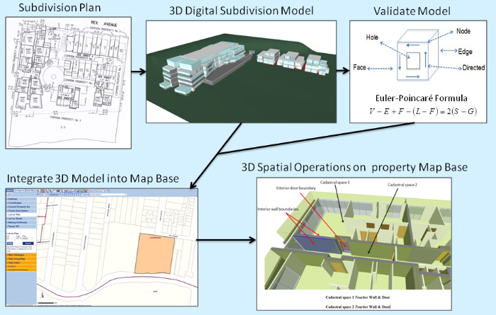
This project aims to develop solutions for accommodating 3D data derived from regulatory urban subdivision processes into the current 2D property ownership map base.
This project expects to generate new knowledge in the area of 3D digital cadastre. Fundamental and applied research in both technical and institutional aspects will be conducted holistically to deliver technical specifications for incorporating spatial information about 3D property rights, restrictions and responsibilities (RRRs) into the map base, and policy recommendations around transforming current 2D-based work processes to support a digital information environment. Current shortcomings in the map base have significant societal and economic implications and are universally experienced, motivating investment and collaboration by the project’s industry partners. This project will address these shortcomings by developing new methodologies in enabling digital integrity and analysis of 3D RRRs and provide the requisite data architecture that the inclusion of 3D RRRs in the property map base is predicated on. This directly addresses fundamental deficits in a core land administration tool and represents a significant step towards decreasing the risks associated with using the map base for decision-making and improving social and economic outcomes for Australia.
The expected outcomes of this project will be guidelines for the delivery of a 3D property ownership map base for smart urban land administration, responding to core business objectives for many governments around the world.
Research team
Prof Abbas Rajabifard
Assoc Prof Mohsen Kalantari
Dr Behnam Atazadeh
Ali Asghari
Maryam Barzegar
Jihye Shin
Industry partners and collaborating organisations
Intergovernmental Committee on Surveying and Mapping
Land Use Victoria (Department of Environment, Land, Water and Planning)
Publications
Book
Rajabifard A., Atazadeh B., Kalantari M. (2019), BIM and Urban Land Administration, Taylor and Francis Group, CRC Press.
Journal articles
Rajabifard A., Atazadeh B., Kalantari M. (2018), A Critical Evaluation of 3D Spatial Information Models for Managing Legal Arrangements in Multi-Owned Developments in Victoria. Australia, International Journal of Geographical Information Science. Published Online June 2018.
Knoth L., Scholz J., Mittlböck M., Vockner B., Atzl C., Rajabifard A., and Atazadeh B. (2018), Cross-domain building models - a step towards interoperability, ISPRS International Journal of Geo-Information - Open Access Journal
Kitsakis D., Kalantari M., Rajabifard A., Atazadeh B., Dimopoulou E. (2019) Exploring the 3rd dimension within Public Law Restrictions, Land Use Policy Journal
Peer-reviewed Conference Papers
Rajabifard A., Atazadeh B., Kalantari M., and Williamson I. (2018) A New Method for Integrating 3D Spatial Information about Vertically Stratified Ownership Properties into the Property Map Base FIG CONGRESS 2018, Embracing our smart world where the continents connect: enhancing the geospatial maturity of societies, Istanbul, Turkey, May 6–11, 2018
Atazadeh B., Rajabifard A., and Kalantari M. (2018) Connecting LADM and IFC standards: Pathways towards an integrated legal-physical model, The 7th Land Administration Domain Model (LADM) Workshop, Zagreb, Croatia, 12-13 April 2018
Kalantari M., & Kalogianni E. (2018). Towards LADM Victoria country profile – modelling the spatial information. 6th International FIG workshop on 3D cadastres, Delft, Netherlands, October 2018
Atazadeh B., Kalantari M., Rajabifard A., & Shin J., (2018). A BIM-driven Approach to Managing Common Properties in Multi-owned Developments. 6th International FIG workshop on 3D cadastres, Delft, Netherlands, October 2018
Shojaei D., Olfat H., Rajabifard A., Kalantari M. & Briffa M. (2018). Moving Towards a Fully Operational 3D Digital Cadastre: Victoria, Australia. 6th International FIG workshop on 3D cadastres, Delft, Netherlands, October 2018
Rajabifard A, Agunbiade M., Kalantari M., Km Y., Atazadeh B., Badiee F., Mond Noor I., Lim Ch., Kamali M., Aien A., Olfat H., Shojaei D., and Rahimipour M. (2018) An LADM-based approach to developing and implementing national 3D cadastre: A case study of Malaysia, Land Administration Domain Model (LADM) Workshop, Zagreb, Croatia, 12–13 April 2018
Kalantari M., Rajabifard A., Williamson I. and Atazadeh B., 3D Property Ownership Map Base for Smart Urban Land Administration FIG Working Week 2017 Surveying the world of tomorrow - From digitalisation to augmented reality Helsinki, Finland, May 29–June 2, 2017
Peer-reviewed book chapters
Kitsakis, D., Paasch, J., Paulsson, J., Navratil, G., Vučić, N., Karabin, M., El-Mekawy, M., Koeva, M., Janečka, K., Erba, D., (2018). Chapter 1: Legal foundations, in: van Oosterom, P. (Ed.), Best Practices 3D Cadastres. International Federation of Surveyors (FIG), Istanbul, Turkey
Pouliot, J., Ellul, C., Hubert, F., Wang, C., Rajabifard, A., Kalantari, M., Shojaei, D., Atazadeh, B., Oosterom, P.J.M. van, De Vries, M., (2018). Chapter 5: Visualization and New Opportunities, in: van Oosterom, P. (Ed.), Best Practices 3D Cadastres. International Federation of Surveyors (FIG), Istanbul, Turkey
van Oosterom, P., Lemmen, C., Thompson, R., Janečka, K., Zlatanova, S., Kalantari, M., (2018). Chapter 3: 3D Cadastral Information Modelling, in: van Oosterom, P. (Ed.), Best Practices 3D Cadastres. International Federation of Surveyors (FIG), Istanbul, Turkey
Janečka, K., Karki, S., van Oosterom, P., Zlatanova, S., Kalantari, M., Ghawana, T., Chapter 4: 3D Spatial DBMS for 3D Cadastres, in: van Oosterom, P. (Ed.), Best Practices 3D Cadastres. International Federation of Surveyors (FIG), Istanbul, Turkey