Completed projects
-
Urban Analytics Data Infrastructure (ARC-LIEF)
A digital data infrastructure that intends to enable the integration, harmonisation, connectivity and scalability of multi-source urban datasets. An archive of one of our completed projects.
-
AURIN & ANDS
The purpose of this project is to facilitate access to data sets for the Melbourne North West corridor. An archive of one of our completed projects.
-
Land and Property Information in 3D
An archive of one of our completed projects.
-
Spatially enabling health data in regional Victoria
An archive of one of our completed projects.
-
Integration of Built and Natural Environment Datasets in the Context of National SDI Initiatives
An archive of one of our completed projects.
-
Incorporating Sustainable Development Objectives into ICT enabled Land Administration Systems
An archive of one of our completed projects.
Past project descriptions
-
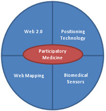
Metabolic GIS
Overview
This project aims at developing an innovative participatory medicine infrastructure by integrating biomedical sensors, geospatial and positional technologies and Web 2.0. This infrastructure enables patients to communicate, to their health professionals, information about their illnesses, and seek advice. The infrastructure empowers public health planning authorities and primary caregivers to utilise a real-time surveillance system to track current and local medical conditions, and provides sickness information to raise the public awareness.
Project Duration
January–December 2013
Researchers
Dr Mohsen Kalantari, Professor Abbas Rajabifard
Funding Source
Centre for SDIs and Land Administration
Research Partner
RMIT University, Melbourne Medical School
-
Can we rely on online maps?
Overview
For the companies such as Google that maintain online maps, the authoritative sources of geographic data are commercially expensive so they tend to use crowd-sourced geographic data in these maps. The public is increasingly using these online maps, nevertheless, the quality and integrity of the data in the maps is not fully known as they are created by an untrained crowd. Yet, the online maps have the potential to contribute to fatal errors particularly in emergency situations. While the use of theses maps by the public is unavoidable, the development of an approach to facilitate the automatic validation of the data in these maps forms the foundation of the proposed study mission.
Project Duration
January 2013 – December 2013
Researchers
Dr Mohsen Kalantari
Funding Source
Department of Business and Innovation
-
National Infrastructure for Managing Land Information (NIMLI)
Project Duration
July 2009–June 2012
Researchers
Professor Abbas Rajabifard, Professor Ian Williamson
Funding Source
ARC Linkage Project
Research Partner
PSMA AUSTRALIA, Landgate (WA), Land and Property Management Authority (NSW), Land Victorian (VIC)
-
Development of Framework to Assess NSDI Initiatives
Project Duration
2005–2008
Researchers
Professor Abbas Rajabifard, Professor Ian Williamson
Funding Source
Space for Geo-Information
Research Partner
Wageningen University, CYTED IDEDES, Delft University, IWT, Leuven University, The University of Melbourne
-
A Marine Cadastre for Australia: Pressing Key Scientific and Policy Issues
Project Duration
2003–2008
Researchers
Dr Phil Collier, Dr Joe Leach, Dr Abbas Rajabifard, Andrew Binns, Lisa String, Sheelan Vaez
Funding Source
ARC Linkage Projects
Research Partner
Land Victoria, Department of Land Information-Western Australia, Department of Lands-New South Wales, Land Information-New Zealand
-
Development of a Metadata entry tool for DSE as part of DSE’s metadata repository project
Project Duration
2007
Researchers
Professor Abbas Rajabifard, Andrew Binns, Dr Moshen Kalantari
Funding Source
CRC, DSE-SII
Research Partner
DSE-SII
-
Designing Land Administration Systems to Support Modern Land Markets
Project Duration
2005–2007
Researchers
Professor Ian Williamson, Ms Jude Wallace (Senior Research Fellow)
Funding Source
ARC Linkage Project
Research Partner
DSE, Victoria; Department of Lands, NSW; Land Information Group, Western Australia
-
Research on SDI related topics and Land Administration Systems
Project Duration
2002–2006
Researchers
Centre members
Funding Source
DSE-SII Research Grant
Research Partner
DSE-SII
-
Concepts and Principles of Virtual Australia, CRC-SI, Project 3.1
Project Duration
2004–2005
Researchers
Professor Abbas Rajabifard, Andrew Binns
Funding Source
CRC-SI
Research Partner
WA, NSW, DSE, ESRI, GA
-
Research to support export of Australian expertise in land administration and marine cadastre
Project Duration
2003–2004
Researchers
Professor Ian Williamson, Dr Abbas Rajabifard
Funding Source
Department of Education, Science & Training Innovation Access Program
-
Defining and Developing a Marine Cadastre for Australia
Project Duration
2002–2003
Researchers
Professor Ian Williamson, Dr Phil Collier
Funding Source
ARC Linkage Projects
Research Partner
Land Victoria, Geoscience Australia and Department of Natural Resources & Mines Queensland
-
Formulating the Next Generation of Spatial Data Infrastructures using Hierarchical Spatial Reasoning and Diffusion Theories
Project Duration
2001–2003
Researchers
Professor Ian Williamson, Dr Abbas Rajabifard
Funding Source
ARC Strategic Partnerships with Industry, Research & Training (SPIRT) Grants
Research Partner
Lands New South Wales