
The 2025 Geospatial Leadership Training and Global Forum for Next Generation of Sustainability Agenda will convene the global geospatial community in Melbourne from April 1-3, 2025
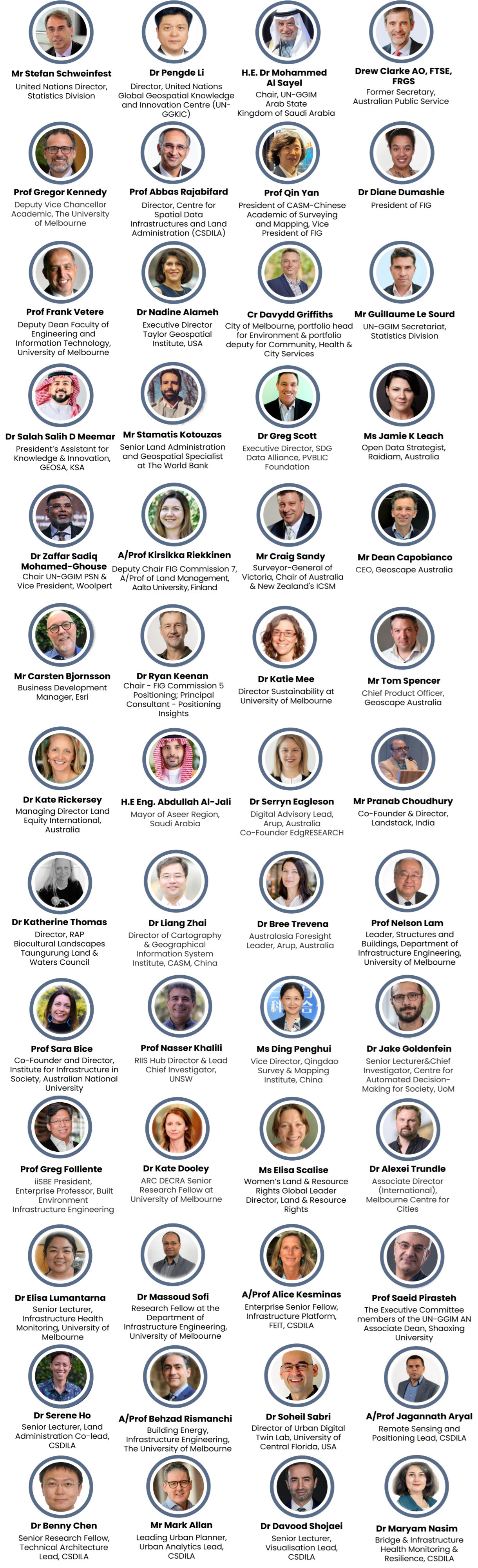
This exciting event, hosted by the United Nations Global Geospatial Knowledge and Innovation Centre (UN-GGKIC) in collaboration with the University of Melbourne’s Centre for Spatial Data Infrastructures and Land Administration (CSDILA) and Chinese Academy of Surveying and Mapping (CASM), will serve as a pivotal forum for advancing sustainable development through geospatial innovation. Building upon the collaborative strength of numerous international organizations, including FIG, UN-GGIM, the Academic Network, Private Sector Network, Geospatial Societies, ISPRS, the Australian Research Council-RIIS Research Hub, and the Geospatial Council of Australia, the forum will bring together global thought leaders from government, academia, and industry. Participants will engage in high-level discussions, share cutting-edge solutions, and explore opportunities to harness geospatial technologies for a more sustainable future.
The theme of the 2025 Geospatial Leadership Training and Global Forum is “Next-Generation Sustainability: Advancing the Future with Geospatial Intelligence”.
As the world confronts the accelerating impacts of climate change, the power of geospatial intelligence to drive informed decision-making has never been more critical. This forum recognizes that accurate, timely, and accessible geospatial data is essential for building climate resilience, mitigating environmental risks, and fostering sustainable development. In the wake of increasing global challenges, the ability to effectively leverage geospatial technologies is paramount to transitioning from awareness to tangible action.
Building on the growing recognition of geospatial intelligence's role in addressing climate challenges, this event aims to accelerate the deployment of geospatial solutions for climate adaptation and mitigation. This includes strengthening the capacity of emerging leaders to utilize geospatial tools for environmental monitoring, disaster risk reduction, and sustainable resource management. The forum will explore how geospatial data can empower communities, inform policy decisions, and drive investments in climate-resilient infrastructure and sustainable land use practices.
The 2025 Geospatial Leadership Training and Global Forum for Next Generation of Sustainability Agenda will therefore focus on "Advancing the Future with Geospatial Intelligence" by showcasing practical applications of geospatial intelligence, fostering collaboration among diverse stakeholders, and promoting the development of innovative geospatial solutions. The event will emphasize the importance of data accessibility, interoperability, and ethical considerations in leveraging geospatial technologies for a sustainable and resilient future. By empowering a new generation of geospatial leaders, this forum will contribute to the global effort to translate geospatial insights into concrete climate action.
The 2025 forum will be held from April 1-3, 2025 in Melbourne, and aims to empower emerging leaders to drive the sustainability agenda through geospatial innovation.
The three-day program will feature:
- A comprehensive Geospatial Leadership Training program designed to equip participants with essential skills.
- A Global Forum focused on addressing critical climate action and sustainability challenges.
This event will foster cross-sectoral knowledge exchange and catalyse new initiatives and collaborative projects within the global geospatial community, contributing to the advancement of a sustainable future.
Program for the Geospatial Leadership Training:
Program for the Global Forum:
The Geospatial Leadership Training Program is a dynamic initiative designed to cultivate the next generation of geospatial leaders, equipping them with the essential skills to drive global sustainable development. Recognizing the pivotal role of geospatial intelligence in addressing critical challenges like climate resilience, equitable land access, and the achievement of the UN Sustainable Development Goals (SDGs), this program tackles the significant skills gap within the sector.
Despite the growing demand for geospatial solutions, a shortage of skilled professionals and visionary leaders hinders progress. To bridge this gap, CSDILA is launching a comprehensive training program, aiming to empower 150 participants with cutting-edge technical expertise, strategic foresight, and impactful leadership capabilities.
This hybrid program, combining immersive in-person sessions with accessible online modules, ensures inclusivity and broad participation, particularly from underrepresented regions and sectors. Participants will delve into critical themes, including:
- Emerging Geospatial Trends: Exploring the transformative potential of GeoAI, Digital Twins, and on-demand ecosystems.
- Geospatial Data for Impact: Understanding how geospatial data drives progress towards the SDGs and climate action.
- Ethical and Innovative Leadership: Integrating responsible and forward-thinking leadership practices within the geospatial domain.
By supporting this program, UN-GGIM has the opportunity to catalyse transformative capacity building, directly contributing to the development of resilient and inclusive societies. Empowering professionals to implement sustainable, location-based solutions within their organizations and communities aligns perfectly with the UN's mission to promote education, innovation, and global sustainable development. This program will ensure the geospatial sector is not only equipped to meet the challenges of today, but to shape a more sustainable and equitable future.
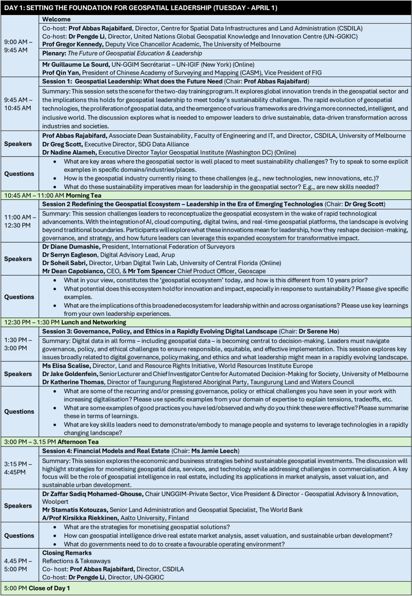
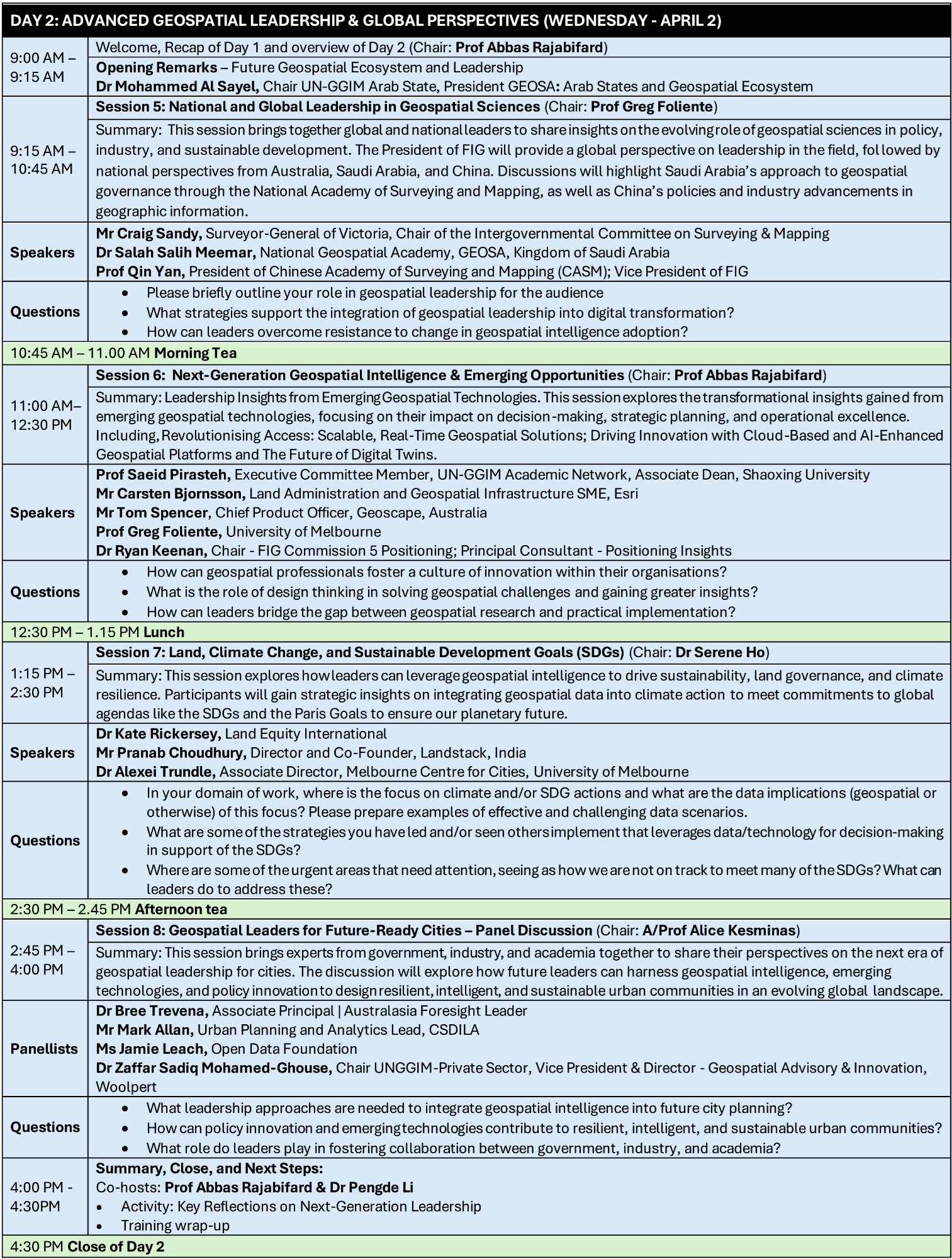
April 1-2 Geospatial Leadership Training
Join a groundbreaking two-day intensive course, led by experts from CSDILA, CASM, and UN-GGIM, designed to transform you into a leader in geospatial knowledge and innovation. This unique training program goes beyond traditional skills development, empowering you to drive strategic change within the geospatial and land administration sectors.
Upon completion, participants will be able to:
- Lead Strategic Geospatial Initiatives: Master the art of integrating innovation, policy, and governance to drive successful geospatial projects within organizations.
- Navigate the Future of Geospatial Technology: Gain a deep understanding of cutting-edge trends, including GeoAI, Digital Twins, on-demand geospatial ecosystems, and machine-actionable data.
- Leverage Geospatial Intelligence for Sustainable Impact: Apply geospatial data to address pressing global challenges, such as climate resilience, equitable land access, and the achievement of the UN Sustainable Development Goals (SDGs).
- Enhance Decision-Making Through Geospatial Insights: Develop advanced analytical skills to effectively utilize geospatial data in complex decision-making processes.
- Champion Ethical and Secure Data Governance: Understand and implement best practices in cybersecurity, data ethics, and responsible geospatial data management.
- Bridge Critical Skills Gaps: Acquire the technical and leadership expertise needed to strengthen national geospatial programs and digital public infrastructure.
- Translate Theory into Action: Develop and execute practical, work-based projects that demonstrate the real-world application of course learning.
This training is not just about acquiring knowledge; it's about empowering you to become a catalyst for change in the rapidly evolving geospatial landscape.
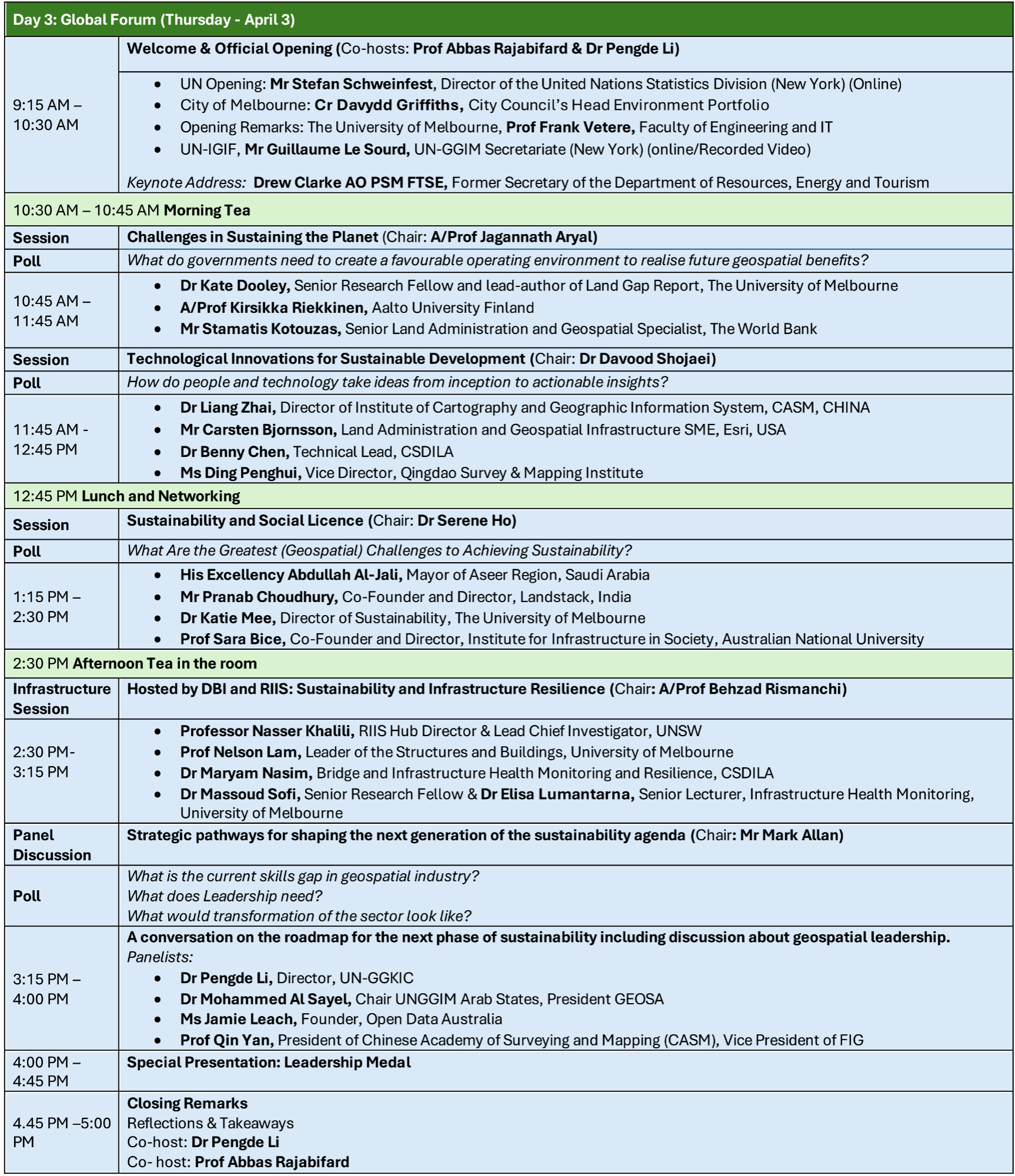
April 3 – Global Forum
Join a dynamic global forum that unites forward-thinking leaders from government, academia, and industry to chart a course towards a sustainable future. Dive into cutting-edge solutions addressing critical challenges such as securing land access for climate action and accelerating progress towards the UN's Sustainable Development Goals (SDGs). This is your opportunity to engage in high-level discussions, share transformative strategies, and forge powerful collaborations that leverage geospatial intelligence to build resilient and inclusive societies.
Benefits of Attending:
- Gain Insights from Global Experts: Learn from leading practitioners and researchers at the forefront of geospatial innovation and sustainable development.
- Explore Cutting-Edge Solutions: Discover and evaluate innovative geospatial technologies and methodologies designed to address real-world challenges.
- Network with Key Stakeholders: Connect with influential policymakers, researchers, and industry professionals from around the globe.
- Contribute to Meaningful Dialogue: Participate in high-level discussions that shape the future of geospatial applications for sustainability.
- Discover Practical Applications: Explore real-world case studies and best practices demonstrating the impact of geospatial intelligence.
- Expand Your Professional Network: Build valuable connections with peers and potential collaborators from diverse sectors.
- Influence Policy and Action: Contribute to the development of strategies and initiatives that drive positive change at local, national, and international levels.
- Stay Ahead of Emerging Trends: Gain a comprehensive understanding of the latest developments in GeoAI, Digital Twins, and other transformative geospatial technologies.
![]()