How mapping has evolved: digital, dynamic and high definition
Traditional, two-dimensional maps just don’t cut it in the modern world of multi-layered infrastructure that includes high-rise, multi-level carparks, tunnels, overpasses and winding highway on-ramps and off-ramps.
Add to these three-dimensional structures the fourth dimension of time, or more specifically, time-poor travellers navigating the complex ebbs and flows of traffic conditions, and this is the new order of mapping that University of Melbourne alum Ali Aien is helping to design.
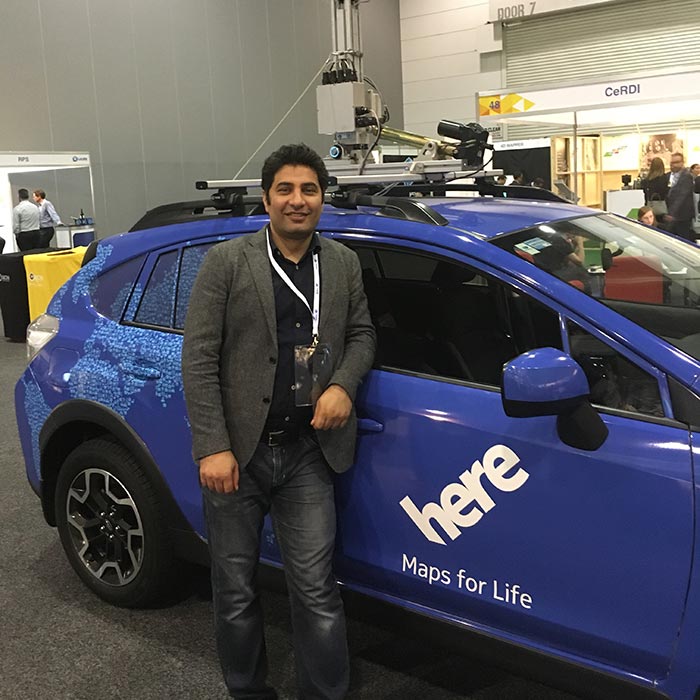
Ali Aien is the Business and Solution Architect Manager for HERE Technologies
Ali is the Business and Solution Architect Manager for the global location intelligence platform company HERE Technologies (HERE). His aim is to help create high-definition (HD) maps with dynamic features that better reflect the real world we live in and move through. While based at the company’s office in the Melbourne suburb of Richmond, his work reaches transport networks around the word.
He started with the company after completing his PhD at the University of Melbourne in 2013, which built on his original engineering degree and focused on geomatics, geographic information systems (GIS) and 3D modelling. Geomatics is a specialised combination of science and information technology.
Applications on the move
HERE is a location data and technology platform that seeks to understand and model a world that is always moving and changing. It produces digital representations of reality; maps that are living, dynamic and continuously updating, covering not just roads but also more of the world in three dimensions such as buildings, factories, universities, retail stores, airports and docks – both indoor and outdoor. Increasingly, it also incorporates the objects that move – vehicles, goods, Internet-of-Things sensors and people.
“Our main task is to understand how people, places and things connect with each other,” Ali explains.
“Our core asset is location data. Big data generated from passenger vehicles, smartphones, trackers, traffic sensors and our own mapping cars. We deploy various machine learning methods to help us build models from the data we collect. Our map data is increasingly automated and self-updating, ensuring continued freshness and accuracy.
“We build tools, services and software development kits that enable our customers to enrich with their businesses, apps or services with location.”
Our main task is to understand how people, places and things connect with each other
He refers to geomatics as providing foundational skills and knowledge needed to apply “spatial intelligence” to processes that combines location-based sensor data with mapping, data analytics and communication technologies. The end result produces new, functional capabilities that enhance the resilience and productivity of businesses.
HERE is a location data and technology platform that seeks to understand and model a world that is always moving and changing
While geomatics can then be applied in diverse fields, from land surveying, transport and planning through to disaster management, Ali says location-based services are the most common use. And most people take advantage of it daily when they simply search for an address, or use smartphone directions to navigate from A to B. There are also more official use cases such as land subdivisions and land surveying.
An autonomous future
When it comes to in-car navigation systems, the challenge is to reflect the real built world with its multi-layered – and sometimes multi-level – intricacies.
“When you’re taking a ramp to the second level of a carpark, for example, a traditional map will find it difficult to represent that,” Ali says. “Or if you want to switch from one highway to another highway and you need to take an off-ramp then take an on-ramp, a 3D representation will give a driver a much better idea of what to expect.”
The importance of his work is set to increase with the inevitable adoption of self-driving cars.
One of HERE’s values is ‘Give back’, and I would like to help inspire the next generation of students with the latest location technologies to enable our autonomous world
“Imagine a self-driving car in a complex area such as a carpark or intersection. An HD map containing lane-based information, real-time traffic data per each lane, and 3D data will be essential for that car to be able to navigate the area. A combination of an HD map and sensors is crucial to these cars being adopted widely.”
After completing his PhD, Ali remains involved with the University of Melbourne through his work at HERE. The company has a Memorandum of Understanding with the University, providing researchers and students with HERE map content and application programming interfaces (APIs) to support research and development projects. Ali liaises between HERE and the University to share the latest developments in industry; he also supports researchers and students by running seminars and lectures.
“One of HERE’s values is ‘Give back’,” he says, “and I would like to help inspire the next generation of students with the latest location technologies to enable our autonomous world.”