Surge capacity analysis and visualisation tool for the Fire Incident Report System (FIRS)
At CSDILA, we harness the power of land administration, geospatial information, and land intelligence to create solutions for a more sustainable, resilient, and connected world. Our research pushes boundaries—transforming the way we govern land, plan cities, manage risk, and shape the built and natural environments. Each of our Research Impact Areas demonstrates how innovative spatial thinking can deliver tangible benefits for communities, industry, and governments worldwide.
Find out about our strategic and major research projects
Overview
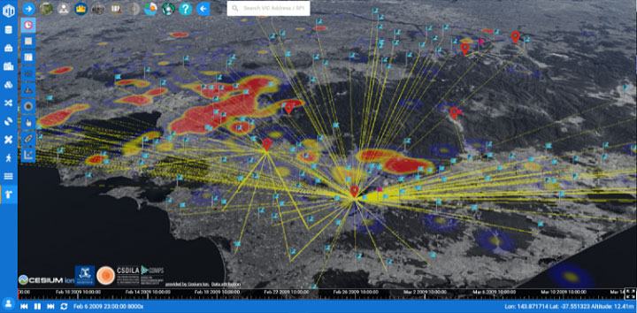
The project develops spatially enabled decision support tool to visualise volunteer firefighting capacity across Victoria and analyses Victoria’s historic peak fire and emergency surge capacity responses from 1999 to 2016. It helps understand volunteer resource supply capabilities in busy seasons and identify research priority needs to enhance volunteer workforce planning capability.
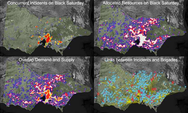
The system was derived from CDMPS’s Intelligent Disaster Decision Support System (IDDSS), which supports enhanced decision making through the provision of better information based upon the ability to visualise databases. The data source comes from the Fire Incident Reporting System (FIRS) which allows reporting on data extracted from fire reports. The research task was determined to be a temporal spatial pattern analysis problem coupled to the definition of concurrency of demand (ie, incidents) and supply (ie, trucks and personnel).
Capabilities
- Visualise the volunteer firefighting capacity across Victoria
- Analyse the historic peak fire and other emergency load surge responses
- Analyse the resources allocation from both brigade and incident perspectives
- Identify research priority needs to enhance volunteer workforce planning capability
Collaborative organisations
Volunteer Fire Brigades Victoria (VFBV)
County Fire Authority (CFA)