2020 news
Professor Abbas Rajabifard invited to speak at the SSSI NSW & WA Online Conference
The SSSI NSW & WA Online Conference will be held on Monday 30 November as part of the Climate Change and Disaster Management (CCDM2020) Week Event and will focus on case studies, technologies, and interactive engagement.
SSSI NSW & WA’s online conference will feature keynote speakers who are leaders in the industry and set the scene for current climate change science. Presenters will give a geospatial perspective on monitoring and analysis of climate change and disaster related events.
Our new collaboration with the University’s Campus Planning and Design Team
3 September 2020
We are delighted to announce our partnership with the University of Melbourne’s Campus Planning and Design team. The collaboration will leverage our Digital Twin for the design and development of an intelligent tool for generating an optimised building envelop based on planning controls. This tool will assist urban planners and designers to achieve good design outcomes that respond to character, microclimate, and heritage.
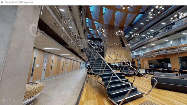
Advancing our Digital Twin Campus to support the University of Melbourne 2020 Virtual Open Day
4 August 2020
We are delighted to announce our partnership with the University of Melbourne’s Campus Planning and Design team. The collaboration will leverage our Digital Twin for the design and development of an intelligent tool for generating an optimised building envelop based on planning controls. This tool will assist urban planners and designers to achieve good design outcomes that respond to character, microclimate, and heritage.
The Centre for Spatial Data Infrastructures and Land Administration (CSDILA) is proud to advance our Melbourne University Digital Twin Campus by scanning and generating 3D models of a selected buildings and laboratories in facilitating the University of Melbourne’s 2020 Virtual Open Day. These models will be used to create a unique and exceptional digital representation of the University’s classrooms, labs, and learning facilities, so that future students, families and wider communities can explore and interact with our campus in Virtual Reality.
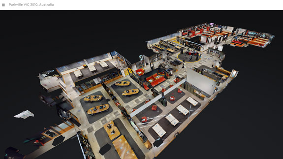
This advancement is part of a bigger project called SpaceMan, which is an ongoing collaboration with the Chancellery, that will include expanding the platform to the entire campus, as well as implementation of additional capabilities to enable and enrich the living Digital Twin environment. The SpaceMan project will be an invaluable contribution to the University’s future asset management.
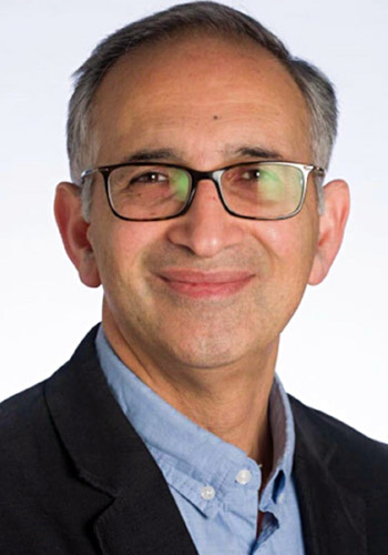
Professor Rajabifard appointed as Director of Smart and Sustainable Development
9 July 2020
We are delighted to announce that Professor Abbas Rajabifard will take on leadership of a new portfolio, Smart and Sustainable Development, for Melbourne School of Engineering. In this role, Abbas will lead research into technological advances to drive economic productivity and enhance a sustainable, secure, and healthy way of life – for our precincts, our state, our country and globally. He will ensure that research, teaching and engagement in smart and sustainable development flourishes and our School is actively collaborating in research within the wider University, industry, and government.
In addition to this strategic role, Abbas will also lead Melbourne School of Engineering’s sector-facing platform in Infrastructure. As the new academic leader of the Infrastructure platform, Abbas will seek to stimulate engagement with the sector and leverage the School’s expertise for lasting impact.
We congratulate Abbas for his new position and wish him all the best luck in his future endeavours.
Latest Research on Sustainability and UN-SDGs
19 June 2020
CSDILA and Centre for Disaster Management and Public Safety (CDMPS) conducted an online open seminar to share the latest research on Sustainability and UN-SDGs at the University of Melbourne. Both centres shared their research work on place-making to build healthy and resilient communities. There was specific emphasis on the following areas:
- Enhancing the methodologies and implementation frameworks to support evidence-based policy making towards achieving the SDGs
- Formalising reusable geospatial tools for producing the SDG indicators, enabling benchmarking and comparison
- Supporting national and local jurisdiction to improve their SDGs implementation monitoring and progress measures
- Assisting governments to predict the future trends of SDG indicators
- Sustainability in curriculum
Dr Gillian Sparkes, Commissioner for Environmental Sustainability, Victoria, delivered a keynote speech and highlighted about the recently released framework for the Victorian State of the Environment (SoE) 2023 report.
The seminar received a great deal of attention from national and international academia, governments, and industry. We would like to thank all the participants and the speakers for their contributions.
2020 Asia-Pacific Spatial Awards (APSEA)
12 June 2020
During the 2020 Asia-Pacific Spatial Awards (APSEA), Abbas Rajabifard was recognised and acknowledged by SSSI, Australia’s peak body in surveying and spatial sciences.
The APSEA celebrate the achievements of top spatial information enterprises and individuals and showcase the finest projects and most significant performance of professionals that the Surveying and Spatial Industry have to offer. Projects and individuals attaining recognition at this premier event are deemed to be truly outstanding achievers and pre-eminent in their field.
Abbas was awarded SSSI Honorary Fellow. This award is in recognition of his significant contributions to the spatial industry in Australia and his leadership at the global level. This award is the highest level of recognition in the membership in SSSI.
Centre for Spatial Data Infrastructures and Land Administration (CSDILA) and Geomatics team at the University of Melbourne are very proud of this achievement. We regard this as a significant accomplishment and a recognition of the discipline’s excellence in Australia and the Pacific.
CSDILA team edit special issue of Remote Sensing
27 April 2020
Members of CSDILA, in collaboration with colleagues at LEISMARS, Wuhan University, and Beihang University, will be acting as Special Issue guest editors in the journal Remote Sensing belonging to the Urban Remote Sensing section. The issue is entitled “Geospatial Understanding of Sustainable Urban Analytics Using Remote Sensing”.
The deadline for manuscripts submission is 30 June 2021, and the issue will be released after the deadline. Papers may be submitted from now until 30 June 2021 as papers will be published on an ongoing basis. If this is of interest, we hope that you and your research team would be able to submit your paper prior to the deadline. We also encourage you to send a short abstract or tentative title to the Special Issue editors in advance.
ePlan and Smart Cadastre Initiatives in Victoria: seminar
25 February 2020
CSDILA and Land Use Victoria jointly conducted a successful and well-attended open seminar with a series of presentations on the advancements in ePlan services (new ePlan Data Viewer and Visualisation Enhancement Tool), digital representation of abstract of field records, update on CAD Co-Design initiative, a proof of concept (PoC) developed for the CAD to ePlan conversion service, and latest research and development update in 3D digital cadastre, 3D data models and connections with the Digital Twin platform. The seminar attracted over 200 industry participants from a wide range of firms.
BIM and Urban Land Administration book launch
25 February 2020
We are delighted to announce the launch of our new book on BIM and Urban Land Administration (published by Taylor & Francis CRC Press) at the open seminar in Victoria’s ePlan & Smart Cadastre.
This book explains the theoretical basis and practicality of connecting urban land administration practices with the 3D digital data environment of Building Information Modelling (BIM). It explains how BIM can be extended with legal data elements to lay the foundation for adopting BIM in urban land administration. The book also highlights benefits and barriers of implementing BIM-enabled urban land administration.
BIM and Urban Land Administration is available to download from the CRC Press website.
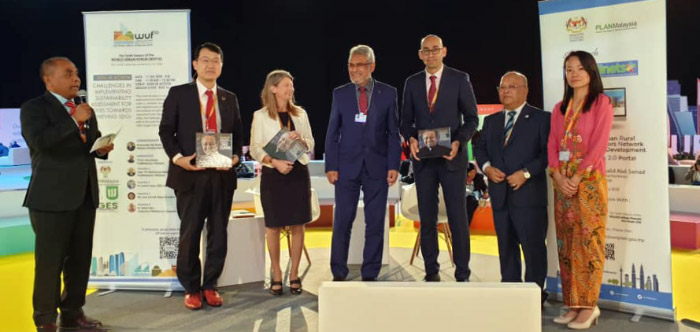
Presenting at the Tenth Session of the World Urban Forum
11 February 2020
Dr Soheil Sabri was invited by Malaysian Government, the Federal Department of Town and Country Planning, to present in a panel at The Tenth Session of the World Urban Forum in Abu Dhabi on 11 February 2020. Dr Sabri presented CSDILA’s research and development on Sustainable Development Goals, on the topic “Spatial Enablement for City Performance Comparison and Measuring SDGs and New Urban Agenda”.