Skip to main content
CSDILA
Research
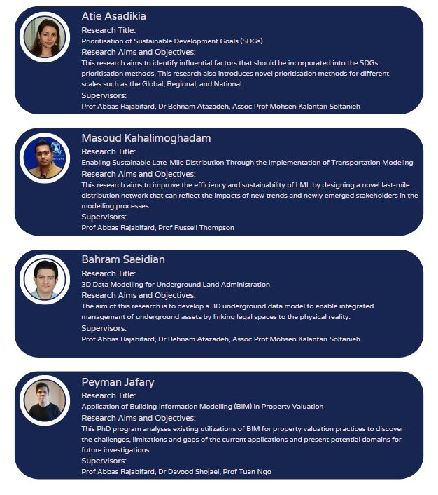
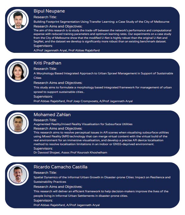
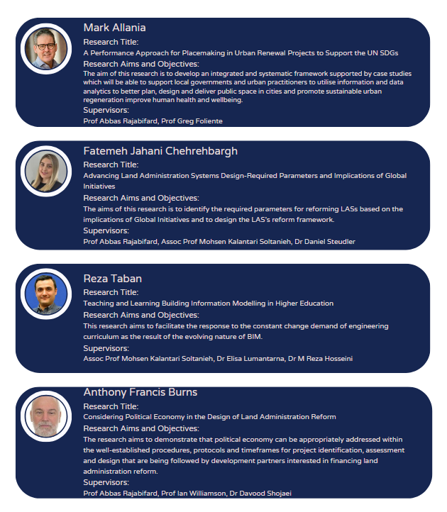
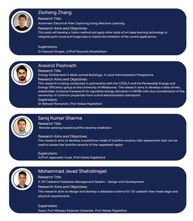
PHD Condidate Reseraches
PHD Condidate Reseraches
CSDILA's diverse range of post-graduate research topics:
CSDILA
About the Centre
CSDILA Structure and Capabilities
News and Events
2024
2023
2022 news
2021 news
2020 news
2019 news
2018 news
Past events
People
Projects
ARC RESEARCH HUB RESILIENT AND INTELLIGENT INFRASTRUCTURE SYSTEM (RIIS) 2022-2027
Infrastructure Protection Utilising Real-time Monitoring of Affected Catchments by Developing Predictive Models During Flash Flooding Events (2023-2025)
Integrating Spatial Digital Twin with Automation System in Smart Infrastructure Asset Management (2023-2025)
Data Integration with Spatial Digital Twin for No Spill Network and Fibre Optic System for Pipeline Monitoring (2023-2025)
Geospatial Routing and Information Visualisation Research Project (Synth) 2022-2023
SmartLand Indonesia (World Bank) 2019-2023
A DIGITAL TWIN FRAMEWORK FOR HUMAN MOBILITY MEASUREMENT IN THE HOME SETTING
e-Plan (Land Use Victoria) 2016-2022
ePlanning and eApprovals Project (Building 4.0 CRC)
Sustainability Fellows (University of Melbourne)
Digital Twin Developments Projects
Fishermans Bend Digital Twin
Coastal flood platform
Development Envelope Control (DEC)
Surge capacity analysis and visualisation tool for the Fire Incident Report System (FIRS)
PedDesign
Digital Twin for Real -Time sensitive urban design decision making
DEVELOPING STRATEGIC INTELLIGENCE FOR THE CONSERVATION REGULATOR (ERP7)
LIVE INDOOR POSITIONING
Live 3D Pose
Spatially Enabled Platform to Support Liveability Planning for a Smart Nation
3D Property Ownership Map Base for Smart Urban Land Administration (ARC)
Singapore 3D Analytics Platform
Malaysian 3D Cadastre
Improving Resilience and Resilience Impact of National Land and Geospatial Systems (World Bank)
Intelligent Disaster Decision Support System (Natural Disaster Resilience Grant)
Planning and Managing Transport Systems for Extreme Events through Spatial Enablement (ARC Linkage)
GeoCity
Natural Hazard Exposure Information Modelling Framework (Bushfire & Natural Hazards CRC)
Urban Analytics Data Infrastructure (ARC-LIEF)
Economic Loss Estimation Modelling (CRC)
Spatial Metadata Automation (ARC)
AURIN & ANDS
Overview
Walkability
Employment
Housing
Health
Resources
Integration of Built and Natural Environment Datasets in the Context of National SDI Initiatives
Land and Property Information in 3D
Spatially enabling health data in regional Victoria
Incorporating Sustainable Development Objectives into ICT enabled Land Administration Systems
Publications
Books and reports
Papers and articles
Papers prior to 2020
Theses
Research
PHD Condidate Reseraches
Digital Twin Developments Projects
Fishermans Bend Digital Twin
Coastal flood platform
Development Envelope Control (DEC)
Surge capacity analysis and visualisation tool for the Fire Incident Report System (FIRS)
PedDesign
Digital Twin for Real -Time sensitive urban design decision making
DEVELOPING STRATEGIC INTELLIGENCE FOR THE CONSERVATION REGULATOR (ERP7)
LIVE INDOOR POSITIONING
Live 3D Pose
D-lab The Museum of Future
United Nations Sustainable Development Goals (SDGs)
Sustainability Fellows (University of Melbourne)
Spatially Enabled Platform to Support Liveability Planning for a Smart Nation
Oil & gas, energy, and mining
3D Property Ownership Map Base for Smart Urban Land Administration (ARC)
Study with us
Contact us
Current Students
Library
Staff